Map to Pickering College
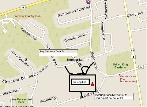
Map to Ray Twinney
Map to Deadman's
Hill 
Map to St. Andrew's College <<< click for map
From Highway 400
- Take exit 55 East onto Hwy 9
- Turn right onto Yonge Street
- Continue south crossing St. Johns Side Road
- Turn right at the lights and enter through gates at 15800 Yonge Street
(St. Andrew's College)
- Take your second right off the main driveway and follow it around
to the gym.
From Highway 404
- Take exit 45 to Aurora Road /Wellington Street
- Turn left off the ramp onto Wellington Street and continue past Leslie
Street and Bayview Avenue to Yonge Street
- At the lights turn right onto Yonge Street
- Drive past 2 sets of lights (at Aurora Heights and Orchard Heights)
- You will see the St. Andrew's front fields on the west side of Yonge
Street.
- Turn left at the lights and enter through gates at 15800 Yonge Street
(St. Andrew's College)
- Take your second right off the main driveway and follow it around
to the gym.
[HOME] [ABOUT US] [RESULTS] [WORKOUT SCHEDULE] [COMPETITIONS] [MAPS]
[RECORDS] [ALL TIME LISTS] [HALL OF FAME] [STEP UP TO EXCELLENCE] [PICTURES] [LINKS]